|

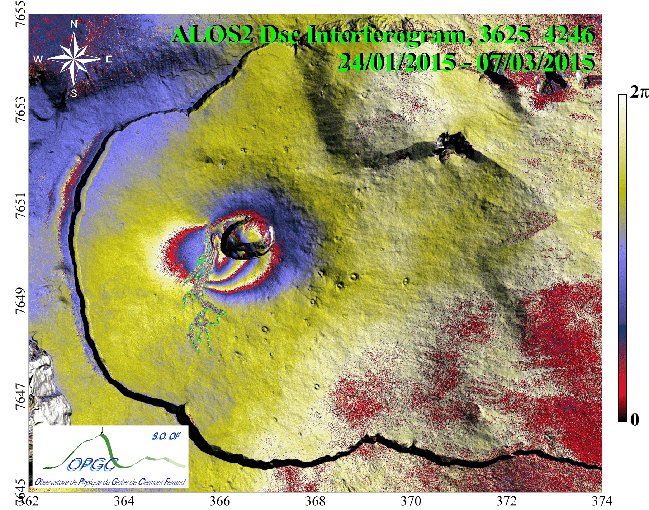
Descending ALOS-2 interferogram 3625_4246 (24/01/2015 – 07/03/2015) showing ground surface displacement related to the February 2015 eruption at Piton de la Fournaise, La Reunion Island. The interferometric phases have been draped over shaded-relief map. A complete cycle of phase (red-blue-yellow) represents an increase in range of 12 cm between the ground surface and the satellite. The location of the eruptive fissure is marked in blue. The lava flow is outlined in green. Coordinates are in kilometers UTM (40 zone South). The interferogram shows an asymmetric bilobate pattern of fringes centered on the western upper flank of the Piton de la Fournaise Central Cône. The main lobe, on the eastern side of the eruptive fissure, accounts for ~ 3 fringes corresponding to a ~ 35 cm displacement to the satellite. The western lobe accounts for ~ 1 fringes corresponding to a displacement of ~ 12 cm away from the satellite. The short-wavelength pattern of fringes, at the eastern side of the eruptive fissure, corresponds to the near-field displacement. It is not visible on X-band or C-band interferograms that have been calculated on the February eruption.
The interferogram was produced by the OI2 OPGC/INSU Observation Service, using the Diapason software (Altamira-Information). The ALOS-2 data were provided by JAXA in the framework of ALOS-RA4 project #1287. This work was supported by public funds from INSU in the framework of National Service for Volcanological Observations
|